Thursday, 31 May 2018

gorgeous granite


Of the eye-catching granite cladding at Centennial Towers, 200 Kent St., Quentin Gall writes...
"Façade and flooring shows classic Rapakivi texture (large ovoid crystals
of alkali feldspar rimmed by plagioclase feldspar) granite. Some
crystals (phenocrysts) are up to 10 cm in diameter. The black matrix
is rich in the minerals amphibole and pyroxene. This unusual rock
contains rare black inclusions. Flame-treated blocks of the same
stone have been used in the walkways surrounding the building."
Gall doesn't specify where these particular slabs came from, but the name is Finnish — Finland and adjoining Russian Karelia are the traditional "type" source for this stone.

Rapaviki boulder, Karelia (source)

Tuesday, 29 May 2018

Glow-fish Approved


Part of this year's "Glow Fair" mural at Bank and Lisgar, work-in-progress by the Fabulous Furry Laporte Brothers. Seaweed to the left is waiting for some fill and I feel a jellyfish about to happen over to the right. Gotta love those Bank Street hoardings that stay up year after year after...

Friday, 25 May 2018

506 Cooper Street


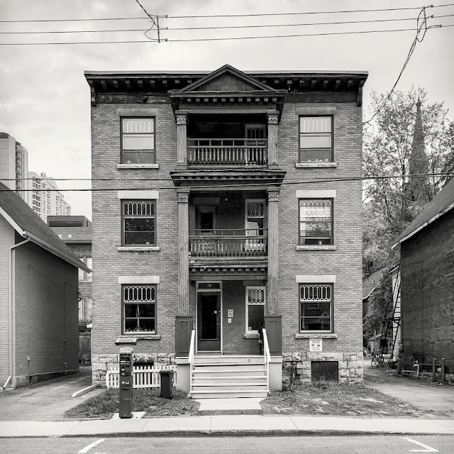
An exercise in late-Victorian asymmetry, this two-and-a-half storey brick-veneered house sits on the southeast corner of Cooper and Lyon Streets. Decorative brick courses relieve the expanse of side walls and shallow-arched window enclosures on the ground floor lend an inviting feel to an otherwise imposing structure. The increasing exposure of the stone foundation from back to front reveals how Lyon's elevation drops from the ridge of Somerset Street towards the valley of Laurier and Slater.

Apparently, the house was not yet built in 1875. Woodburn lists all of six households on Cooper Street that year. "Concession st." is now Bronson Avenue.


Once again, I'm finding that the City Directories lagged behind Goad's maps in listing new addresses. For example, Polk & Woodburn 1890-91 list only "Vacant lots" running up to the Lyon intersection, even though Goad 1888 (sheet 55) depicts this house already built.

My next directory, Might 1901, lists John McLaughlin at #506. I figure McLaughlin as the builder/ first occupant — he owned the Ottawa Stair Works at 286 Bank.

Might Directory, Ottawa 1901

Shortly after this ad was published, McLauglin moved his business to 989 Somersets Street West, presently the address of "A Fine Thing" antique dealers. See discussion here.


Ottawa Journal, February 25 1914

Mr. Mclaughlin was still residing at 506 Cooper at the time of his death.

The house seems to in a good state of repair. Google Street View indicates that the front porch was refurbished in 2007, and the present occupants have turned the front yard into an inviting garden.

Sunday, 20 May 2018

You're invited!

This is me being snarky snarkier than usual — really though, aren't editors paid to notice this sort of thing?

from The Ottawa Journal, May 8 1946, page 12

Well that's just swell.  Now everyone and their dog knows that a frail-looking 80-year-old by the name of Damase Laframboise who lives at 69 Sweetland Avenue has a LARGE SAFE in his house.  What more could someone have written on page 24? I can only speculate...

Has Large Safe
(continued from page 12)
Armed thugs who broke into the home of Damase Laframboise last night had no idea that they'd entered the home of a frail old man who keeps a LARGE SAFE in his house at 69 Sweetland avenue in Sandy Hill (see photo page 12). 

Like many older folk, Mr. Laframoise doesn't trust banks and keeps his valuables at home in a LARGE SAFE. His hoard includes family heirlooms in gold and sterling, an album of priceless, one-of-a-kind postage stamps, and, as he proudly pointed out, "many" bundles of high-denomination bank notes.

The would-be thieves likewise failed to realized that the oil painting of a ballerina above Mr. Laframoise's living-room couch is an original by the French artist Edgar Degas worth many thousands of dollars.

Mr. Laframboise's live-in niece, Eva Therien, keeps a black laquered chest (directly under her bedroom window). This is stuffed with unworn women's "foundation" garments into which are sewn Colombian emeralds, Australian fire-opals, Ceylonese rubies as well as diamonds from Africa's Kimberley mine. She claims to have gotten the idea for this from reading about the Romanov princesses in Reader's Digest.

Neither Mr. Laframboise nor Mrs. Therien owns a dog, though, as they laughingly pointed out, a blue budgie, "Robert", lives in their kitchen. They reside at 69 Sweetland (with a LARGE SAFE), in Sandy Hill between Osgoode and Somerset East, on the east side of the street. The address sits on an incline, so don't forget to use your parking brake!

Ragsil Court

421 Lisgar Street, Ottawa, built circa 1913
My earliest Goad map dates to 1875 and shows a tiny wooden house at 421 Lisgar, this at a time when the street marked the southern boundary of Ottawa's urban spread. The house appears on Goad's 1912 "reprint", in which year the Might Directory listed it as "vacant", still so in 1913. Might 1914 gives us "Ragsil Court" — the building we see here — with six units including one for the janitor (at the time, one George Johnson).

The style, going by date, is some flavour of the late Edwardian, and a classical last stand at that. Indeed, the Ragsil would have been party to the final huzzah of the limestone foundation in this city — World War One and poured concrete were waiting in the wings.

I want to believe that the leaded window treatments are original. The windows themselves mark the transition from limestone sills to "sandstone" lintels. The uprights in the balcony railings bow outward, alluding to properly turned balusters while the columns suggest an Egyptian* play on the Corinthian order — papyrus and nodding lotuses instead of acanthus? — almost deco — but hey, I'm just guessing.

The name is odd. "Ragsil" is largely search-proof and the few meaningful returns discuss anagrams. And look, Ragsil is an anagram of Lisgar. In fact, it's Lisgar spelled backwards.


*Suez Canal completed - 1869
 Aida (opera) premieres - 1871
 Cleopatra (movie) opens, starring Theda Bara (an anagram for "Arab death") - 1917


Tuesday, 15 May 2018

life during wartime


Canada's "Wartime Housing Limited" was the precursor to our present-day CMHC. An understanding of the former's history and achievements can gleaned from Jill Wade's Wartime Housing Limited, 1941—1947: Canadian Housing Policy at the Crossroads (June 1986). Her complete essay can be viewed/download here.

She frames her investigation with this introduction...
"Beginning in 1941, a federal crown corporation called Wartime Housing Limited (WHL) built almost 26,000 rental housing units for war workers and veterans. It was a successful yet temporary phenomenon. Six years later, Central Mortgage and Housing Corporation (CHMC) absorbed and dismantled the wartime company. Eventually, CMHC made possible the tenants' purchase of the WHL units.

In 1944, while WHL efficiently performed its construction and management operations, a report issued by the housing and community planning subcommittee of the Advisory Committee on Reconstruction described the enormous contemporary need for low and moderate income shelter in Canada. The report recommended a nation-wide, comprehensive, and planned program emphasizing low-rental housing. Instead, the federal government initiated a post-war housing program that promoted private enterprise and home ownership and neglected long-range planning and low income housing.

Thus, an interesting question follows. Why did the federal government not reconstitute WHL as a permanent low-rental housing agency to meet the huge low income accommodation need following World War II?..."

 Jill Wade was born in 1942 and raised in St. Boniface, Manitoba. She taught British Columbia history in the university program at the Open Learning Agency in Burnaby and published Houses For All: The Struggle for Social Housing in Vancouver, 1919-1950 (UBC Press, 1994). (source)

Monday, 14 May 2018

mid-century home-building porn, maple-bacon style


Cover design, 67 Homes for Canadians, CMHC, February 1947 — you can view/download the entire document here. Below is Plan 47-19, i.e. nineteenth in the 1947 series.
Click on the pix to aggrandize.

From the foreword of 67 Homes...
"There has long been an urgent demand in Canada for new, attractive designs of low or moderate-cost houses suited especially to the Canadian way of living.

The purpose of "Homes for Canadians" is, in part, to help meet this demand and to provide the prospective house builder with general information on financing, costs, site selection, construction standards and planning.

This book is divided into three sections. The first contains a broad discussion of the above-mentioned subjects. The second presents 30 new designs for essentially Canadian homes. The third contains designs submitted by prize winner on the recent Canadian Small Homes Competition.
It is our hope that "Homes for Canadians" will help to meet an ever-increasing demand for information of this kind.

[signed]
D. [David] B. Mansur,
President
Central Mortgage and Housing Corporation.

Ottawa, February 1st, 1947"
 And some historical context from CMHC (original here)...
"...In 1946, shortly after World War II, CMHC (first known as Central Mortgage and Housing) was created at a time when Canada faced a massive housing shortage. The immediate challenge was to find housing for the thousands of returning veterans. In the process, CMHC helped create entire cities, such as Ajax, Ontario and Gander, Newfoundland. Thousands of storey-and-a-half houses across Canada were built by CMHC in the years following the war, bringing about new neighbourhoods, towns and cities. In the absence of a co-ordinated building industry, CMHC stepped in to deal with every aspect of housing servicing land, building and selling housing and arranging mortgage financing.

Before CMHC and its planners became involved, cities had grown with little forethought as to where things should be built and what kind of services would be needed. CMHC, through its housing designs and neighbourhood plans, began the first efforts towards the co-ordinated growth of Canadian cities, with housing mixes suitable for a variety of residents, from singles to families and seniors. It was CMHC s influence that led in the development of the first schools of urban planning in Canada.

Even the actual lay-out of neighbourhoods was affected by CMHC: the curved streets, courts and crescents so much a part of the Canadian city s landscape owes much to Dave Mansur, CMHC s first president, and CMHC s planners of the day, who worked to find ways to slow down traffic in residential areas. That rationale is still used in developing new neighbourhoods today.

In the 1950s, when other lenders assumed financing as a private business, CMHC turned to mortgage loan insurance, which guarantees the lender will be re-paid if the homeowner fails to keep up the payments. That assurance has helped keep mortgage rates down and housing affordability up. It also meant that mortgage money was available not just to Canadians in larger cities, but in remote and rural areas of the country.

Over its 50 years, CMHC has been heavily involved in research. At first, it focused its efforts on the technical issues, helping the construction industry solve problems dealing with foundations, drywall, roofing and other construction components. "CMHC approved" is the assurance of quality..."
(This house guaranteed "Flintstones-ready";-)

in the run-up to WWII

The Winnipeg Tribune, July 2 1938

Sunday, 13 May 2018

say nice things about Ottawa


So I figured I'd pass along this blurb from Shell Oil's roadmap of downtown Ottawa, 1948. To its nameless copywriter*,  kudos for spelling "Philemon" correctly, you've no idea how many Ottawans can't. Think "-lemon", like the fruit.

Seventy years on, we do not describe people as either "swarthy" or "picturesque". Even if they are.

In a letter dated December 31 1857, Queen Victoria notified our Governor General that she had chosen Bytown as Canada's capital,  In fairness, and given the shitty state of the internet back then, none of us would have actually gotten the news until 1858 — the first ever transatlantic cable message would be sent some six-and-a-half months later, on August 16, 1858, between Ireland and Newfoundland.

Also note that in 1948, the National Art Gallery was housed with the nature collection at the Victoria Museum, now the Canadian Museum of Nature, on McLeod. The Archives were stored in a purpose-built "Tudor Gothic"-style building at 330 Sussex (extant) while the "Military Museum" (not mentioned here) was crammed into a shoebox-shaped government building next door at #350 (since demolished).

Thursday, 10 May 2018

the past inside the present

Bank Street and Laurier Avenue West, northwest corner, rear view

152-162 Bank, a cluster of older commercial buildings hunkers down amidst newer arrivals. The five-storey building at #162 replaced a row of low (1 to 2½ storey) wooden and brick-veneer storefronts.

A fanciful oddity appears directly north of this spot on Goad's sheet #41 for 1878...


A defiantly angled two-storey brick house at #142 Bank once sat in the space now occupied by the little parkette/vacant-lot — where pigeons congregate  beneath the "G.A. Snider Photographer" ghost sign. Woodburn (1875) gives "Rogers John, boarding house" and  "Binks Wm, printer" for that address.

Wednesday, 9 May 2018

"What do you see... the future?"


The Dandy's Perambulations by Isaac Robert Cruickshank

Perhaps I'm veering off topic here, but it just occurred to me why "Draisienne" two-wheelers were called "dandy-horses" — and it wasn't because they were cool, neat, spiffy or swell.

When I first encountered the above book of "caricature engravings" some months ago, I assumed that writer-illustrator Robert Cruickshank didn't know how to draw a proper bicycle. As it turns out, there were no "proper" bicycles to draw in 1819 — they hadn't been invented yet. Rather, he was drawing was what had become a fad among dandies (hipsters, macaronis, fops) who propelled these mounts, hither and fro, by running while seated. Indeed, the bike's inventor, the German Baron Karl von Drais, called his device the Laufmaschine, literally the "running machine". The publication date of Cruickshank's storybook is telling, as the dandy-horse craze peaked briefly in England and France, in the summer of 1819.

View this delightful document in its entirety here, and take heed when our protagonists are set upon by geese  — 'tis a hazard not to be taken lightly.

Drasiennes R 4 kidz!

Tuesday, 8 May 2018

Love at First Bike

the Ottawa Journal, April 1898
The first bicycle (sensu lato) dates back to the early 19th century (the wooden "Draisienne", see below*), but it was the introduction of the Dunlop pneumatic tire in 1888, and the development of the freewheel/coaster-brake in the 1890s that fomented a true fin-de-siècle cycling craze. Given the Ottawa's road conditions at the time (mud, cobbles, streetcar rails), one wonders exactly how much fun bike-riding would have been. Of course, we had little to compare any of that to.

At first, opening a store that only sold bicycles must have seemed a bold move — safer to carry them seasonally, alongside agricultural equipment as in the above case.

So many old newspaper ads fail to give full and proper street addresses. In the present case, "Cor. Sparks & Kent Sts." is almost generous. My research indicates (Goad 1888) that Massey-Harris sat on the southwest "Cor." of Sparks and Kent. In time they were replaced by the Esdale Press bookbinders, as the selling of farming tools in the heart of a business district became ever less appropriate. The location is now a Starbucks in the Marriott Hotel at 100 Kent Street.


 *Developed 200 years ago by the Baron Karl von Drais (1785-1851, Karlsruhe Germany), the Laufmaschine ("running machine"), Draisienne, or "dandy-horse" featured what we would now call "Fred Flintstone drive". Drais anticipated key features of modern bike design, including front-wheel steering — still, riding one would have been strenuous (if not outright murder on the crotch). Drais' October 1817 brochure for the Laufmaschine took pains to stress the graceful integration of rider and machine (image of a military courier above) — note his depiction of optimized posture, stride and the toe-strike/push-off positions of the feet. Cue Kraftwerk.

summer kitchens and sheds out the backside

227 Nepean, from behind
227 Nepean Street was built some time between 1878 and 1888 if we are to rely on its first appearance on the Goad maps. Mr. Goad shows it thus in his 1912 reprint...

Goad sheet 38, detail
I didn't take this photo to highlight anything extraordinary about #227, rather to point out a feature common to so many smaller Victorian era houses in this city — the summer kitchen. This appendage appears in the photo as the pitch-roofed section directly behind the main house, set off-center from that structure, probably to simplify laying the foundation. Goad shows both the main house and summer kitchen in yellow bordered with red — wood construction veneered with brick. The summer kitchen is marked "1½", indicating one full floor plus a "half floor", that is, one without a full-sized ceiling. Proceeding north therefrom and coloured in grey, we have a probable wood/coal-shed, a likely tool-shed and, marked with an "X", the horse-shed, or as some people would call it, a "stable"*.

The idea here (as I've been led to understand by people who actually know about these things) is that houses like these were configured to rely on kitchen stoves for much of their heat. This became a problem in summer, when cooking and baking continued apace, sans microwave, sans AC — hence the need to get the offending appliance at least partway out of the house.

I've seen enough photo's of families carting their wood stoves with them on picnics to be convinced that moving one from the main kitchen (main floor rear) out to the adjoining summer kitchen would have been no big deal, viz the James Ballantyne family out for an excursion in Rockcliffe Park.

 circa 1893, James Ballantyne fonds, via
Note the wood-burning stove at the left of the image. Incidentally, I've researched this photo and anyone wishing to stage a re-enactment should set things up right about here.


* This cluster of sheds has given way to what looks like a more recent granny-shed or "granny-flat".

Monday, 7 May 2018

@boodzz

One of only a handful of sticker artist happening in Ottawa these days...

Downtown Ottawa, 1948

click to make bigger, add to your collection!

Falling Down


Spring brings the renewed demolition of the London Arms Apartments (originally the "Midtown") built in 1938 at the corner of Gloucester and Metcalfe (see Chris Ryan's article). A fresh assault on the southeast corner of the building reveals extensive use of concrete cinder-block.

the Ottawa Journal, September 10 1938

what, no Klieg lights?

not the Guggenheim, Byward Market Ottawa
From the Ottawa Journal, November 4 1959...
The spacious and ultra modern Freiman's Parking Centre, hailed as "a milestone among shopping and parking facilities on the North American Continent", was officially opened last night glitter usually associated with a Hollywood premiere.

Only the traditional kleig lights were missing as a 50-car cavalcade, led by Mayor [optician George] Nelms' chauffeur-driven limousine, pulled up before the white ribbon stretched across the entrance to the imposing new building on George [no relation] street.

Alighting from his car, Mayor Nelms shook hands with Lawrence Freiman, president of A.J. Freiman Ltd., congratulated him on "insight" shown in establishing a much needed facility in the city and sliced through the ribbon across the entrance...
The article mentions the structure's 403 parking spots spread over five tiers, the 251-foot climate-controlled tunnel connecting it to Freiman's department store and the "handy counter-to-car automatic [?!] package conveyor".

The balance of the piece is given over to people hopping in and out of Cadillacs and otherwise seeing and being seen while saying nice things about each other. Interestingly the thrust of the conversation seems to have been the importance of bringing cars into the Byward Market.

This, we should remember, was at a time when the Market was the place to see drunks and prostitutes, visit the shops of Jews who sold used furniture, fruit and vegetables, cheap and funky clothing (Sir Plus!) and kitchenware (enamelware from China!) — also to buy from farmers who spoke French and sold local produce including kittens and live chickens — all of which is to say, a real market.

Now we have drunken students, tourists and crackheads. plus ça change...

Sunday, 6 May 2018

Janeville, '79

From the 1879 Belden Atlas of Carleton County — captured from a PDF so the resolution is a bit hinkey. Click on the pic to read the little words...


Of the Janeville period of Vanier's history, Alan McLay reports on a presentation by local historian Robert Serré (Historical Society of Ottawa, Jan. 2009)...
"...Janeville developed as an urban suburb in the midnineteenth century, a place for well-to-do residents to find peace and quiet. It was located in Gloucester Township east of the Rideau River between Montreal Road on the north and McArthur Avenue on the south. To the east lay the tracks of the Bytown and Prescott Railway, which were completed in December 1854.
One of the earliest settlers in the area was Charles Cummings, who bought the island in the Rideau River in 1836, which he called Cummings Island. By 1843 a bridge had been built across the river to Rideau Street in Ottawa. His son Robert became a carriage maker and he later served as the Reeve of Gloucester Township.
Another early settler was Donald McArthur, who had come to Bytown in 1827 and built a hotel on George Street. In 1833 he bought property in the southern part of the area that was later to be called Janeville. In 1873 Donald McArthur and Robert Cummings established the village of Janeville, named after Donald’s wife Jane.
In 1879 [the year of the above map] a post office was opened on Cummings Island. The first postmistress was Mrs. Agnes Cummings, who held the position for 42 years. By 1879 there were eight streets and 56 families living in the village. Most of the early residents were Anglican.
In 1887 they built St. Margaret’s Church on Montreal Road on land donated by the Olmstead sisters, the daughters of Gideon Olmstead, another early settler.The stone used in the construction of the church was provided by Honoré Robillard, the owner of the Gloucester Quarries..."
Montreal Road is still very much with us, as is McArthur Avenue, both seen here crossing Mr. Belden's map.  The train tracks, designated "St. Lawrence & Ottawa Railway" (1867) are those referred to as the "Bytown & Prescott" (1854) by McLay and Serré in the quote, Ottawa's first inter-city rail line. That rail right-of-way is now the Vanier Parkway.

Notice the properties to the lower right owned by Mrs. D. McArthur. This, I dare to presume, would have been Jane McArthur for whom the community was named.

The "road allowance" at the top of the map would become John Street, then eventually Coupal Street (west of the tracks) and Deschamps Avenue (east thereof).

Hannah Street is still Hannah Street, but many of the names used in 1879 have changed. Working (roughly) from west to east...
Russell Road > River Road
John (not the "John" mentioned above) > Selkirk
Victoria > Montgomery
Ann  > Desrosiers
Railroad  > St. Paul
Catherine > Durocher
First, Second & Third Avenues > Kendall, Savard & Cyr Avenues
George St. > Cody Ave.
Olmstead St. didn't exist at the time
Hill St. > Lévis Ave.
Charles > Dupuis
Maude > Bégin
Centre > Lajoie
The roadway designated "held by D. McArthur" is now Jeanne-Mance Street, which dog-legs north at Lajoie to become Blake Bouldevard.
When studying a map like this, we should bear in mind that survey lines do not houses make. Properties can be subdivided for quite a while before houses are built upon them. Likewise, this is not road-map — sometimes, lines that look like roads are no more than good intentions.

I mention this, first to point out that "Janeville '79" wasn't quite the ordered suburb we see on Mr. Belden's map. Second, I wish to focus attention on the grand swath of land to the upper left of the map, lying between the Rideau River, Montreal Road, and the train tracks. It contains seven longish strips of land that might have lent themselves to farming but were in fact largely waste ground until the mid-20th century. I have to believe that this sort of thing happens — or in this case fails to happen — for a reason. Further attention is called for.

Tuesday, 1 May 2018

Echo Drive at Mason Terrace

GeoOttawa lists this address as 619 Echo Drive and indicates (aerial photography) construction some time after 1928 but before '58. I'd stop just short of describing the neighbourhood as "posh", but it does boast many uniquely designed, well-maintained houses on nicely treed lots.

This part of Old Ottawa East, especially the area across the Rideau Canal from Lansdowne Park, has seen several houses original to their sites lately replaced by grander statements — 621 Echo next door being just one example.


#619 occupies the center of this 2015[?] aerial view. The two-storey wooden structure was attractively sheathed in some sort of white stucco. Note how the garage faced onto Mason Terrace. A strange vestibule-like structure reached halfway across the front yard toward the sidewalk. A ground-floor sun-room on the northwest side of the house caused the frontal asymmetry visible in the upper photo.

I question the date of geoOttawa's aerial view because it looks like spring to me, but a Google Street View from September of 2015 shows the twin-trunked front yard maple tree in the process of removal. Here it is already gone. Whatever. It's still gone.